
The first documentary reference to Barcheston occurs in the survey of England made in 1086 on the orders of William the Conqueror. Known to us as Domesday Book but to contemporaries as the Description of England, it reveals both the state of the country twenty years after the Norman invasion and also gives a picture immediately before 1066(1). Its terminology, whether of land measurement or the legal status of the inhabitants described, is hard to understand and the present interpretation may raise some eyebrows.
It is clear from its pages that there were already two settlements in the Saxon parish of Barcheston. Their Saxon lords were named in Domesday Book because all were displaced and their lands given to Normans. The king was the technical lord of all the land in the kingdom. His tenants owed him not only allegiance but service; three of the men to whom land in Barcheston parish was given, its overlords, were of Norman birth and were probably absentees; whether their tenants, the men whose names are recorded were resident is not stated.
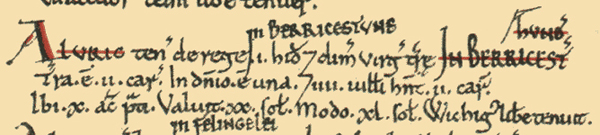
Barcheston Domesday book extract courtesy of Professor John Palmer and George Slater http://www.domesdaymap.co.uk
In the time of King Edward the Confessor (c.1003-1066) the settlement at Barcheston had been the possession of one man, Wiching; by 1086 it had been divided, unequally. The value of both parts had increased, albeit not by the same ratio. 16 men were identified, by their different legal status, suggesting a total resident population of around 100 people. Aelfric who held the smaller part of Barcheston itself, 1 hide and ½ a virgate, held directly of the king. His demesne, the land he cultivated for his own use, was worked by one plough while the four villeins (men with some land of their own) were said to operate two. Additionally, Aelfric had 10a of meadow and the whole estate was valued at 40s (£2000), double its previous value.
Johais held the second, larger manor of 2½ hides as a tenant of William FitzCorbucion. There were five villeins; seven others were described as bordars and possibly had a house and garden of their own. Between them they operated 11/2 ploughs, while Johais had two ploughs to work his demesne land. He also held a mill worth 100d a year (about £415 in today’s values) and 12a of meadow. The whole was reckoned to be worth 50s, (£2,500 today), a figure 25% higher than before the Conquest.
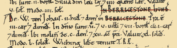
Barcheston Domesday book extract courtesy of Professor John Palmer and George Slater http://www.domesdaymap.co.uk
In Willington the two Saxon owners, Doda and Leofric and Alfward, were also dispossessed; both holdings were valued at 20s.(£1000). Their land was passed, presumably preserving the old boundaries, to two holders. Robert de Stafford was overlord to Ewein who had land for two ploughs and commanded two serfs (men without their own land), one villein and one bordar (a small holder). The absentee landlord of the second manor, Gilbert of Ghent, kinsman to the king and later earl of Lincoln, held 1 hide and 1½ virgates. He sublet the land to Fulbric who enjoyed land for one plough and the services of one villein, two bordars and four serfs. He also had a mill worth 5s. (£250) a year and 15a of meadow. The figures indicate a population of around 70 people.
The suggestion is that the land was used primarily for arable farming.
Thereafter the settlements are treated separately in documents and, apart from the fact that the inhabitants attended the same church situated in Barcheston, appear to have functioned independently.
References:
